Travel Journal
Colorado Trail day 9
July 03, 2026
We got up a little before and a little after six respectively. We had only one hot drink this morning and split a protein puck. We wanted to get an early start so that we could get into Breckenridge and Frisco to deal with some things before the Fourth of July. We ended up getting on trail at 7:45.
The trail climbs fairly steeply out of the valley where the Swan River is. We climbed 1300 feet in just 2 1/2 miles. We took a couple of little breaks to eat some protein bars on the way up. Near the top, we met a CDT hiker with trail name Trash Lobster. We talked to him for a few minutes while some mountain bikers rode by. He is over two months into his hike.
We noticed that much of the forest we walked through this day had been thinned, both small trees and mature areas.


As we walked around the high point of the trail for today, around 11,000 feet, we got views of the Keystone ski area.  We talked to several other people, I think partly because this part of the trail is the Continental Divide Trail as well as the Colorado Trail, and also because people from Breckenridge and Frisco access it for day hikes or rides - there were lots of bikes.


We passed the 100 mile mark on the trail in the afternoon. As we finished a little song we sang there a CDT hiker arrived. We spoke with him a bit and it turned out we were able to give him some water so he could make it over the hill to the Swan River where we’d come from.


We arrived at the bus stop on Highway 9 just six minutes before the free bus to Frisco arrived. Instead of going directly to our friend’s townhouse in Frisco we were looking for an optical store because one of the nose pieces of Julie’s glasses had broken. Some local folks on the bus recommended a place near the transit station and gave detailed directions.
We found the Eyetech store. Julie showed them the problem and they quickly replaced the nose pieces on her glasses and then refused any payment. Since we were at a shopping area we picked up a bottle of wine so we wouldn’t arrive empty handed. On the bus back towards the townhouse we talked to some other through-hikers and they had some advice about bypassing the closed trail segments.
With all that feeling of generosity we arrived at our friends John and Norma’s townhouse and their generosity was overwhelming. We sat on their deck and had wine and appetizers.

We showered while they got dinner ready. We had planned to take them out to dinner but they pointed out how full the town was and that the restaurants would be packed. They served a simple but tasty dinner and we caught up and talked about our trip and logistics. Then we got to sleep in beds with real pillows.
13 miles with substantially more descent than ascent over 7 hours.
Colorado Trail day 8
July 02, 2026
We slept fairly well. It was chilly but nothing that couldn’t be managed by wearing our puffies inside our sleep systems. Julie got up around 5:30 and I stayed in bed for a little while longer.
There was a big valley to the east of us with a ridge on the other side. The sunrise over the ridge was a bit dramatic because the smoke had returned overnight.

It was a pleasant campsite and a chilly morning, and not a lot of miles for the day, so we decided to take our time getting going. We also had a one or two bars of Verizon service, so I managed to update our blog with two more days (days 4 & 5) of text and photos.
We got on trail at 8:30 and hiked a little over a mile to a creek so that we could refill our water supplies. Then we continued slowly climbing towards Georgia Pass.

There were expansive views as we neared the pass, but the views to the north and west were hazy with smoke. This is the first major mountain pass of the Colorado Trail southbound so it felt like a big accomplishment.


After the pass we had a gentle descent for several miles that quickly went into a Lodgepole pine forest. We finished listening to The Midnight Feast by Lucy Foley, an audiobook we had been listening to for several days. We enjoyed the mystery and the story, although the narrative jumps back and forth in time a bit too frequently. We stopped for lunch and made curry chicken salad (based on a Chef Corso recipe) on crackers.  After a few miles, it got very rocky and pretty steep with some tough footing.
At the bottom of the valley, where we cross different forks of the Swan River several times, we were surprised to see a huge dog kennel area. It looked like there were a number of sled dogs.

We stopped to set up camp at about 4:00 in an area with several campsites near the North Fork of the Swan River. This river will be the last water available for several miles as the trail goes up and over a ridge south of the Keystone ski area then towards Frisco and Breckenridge.
Probably because of the water situation there were several other people camping in the dozens of sites.

We made some African peanut soup using instant sweet potatoes, peanut powder, and peanuts with spices (another Chef Corso recipe). Then we filtered a whole bunch of water so that we could get an early start tomorrow. We switched to using our backup water filter and it is so much faster than the one we had been using – we will just have to replace that one.
While down at the water we talked for a while to a young man and woman who had met on the Appalachian Trail and were two months into hiking the Continental Divide Trail. They were carrying a funny combination of minimal gear along with some impractical souvenirs from the journey. It was unclear if they were a couple or just hiking buddies, but he had gifted her an old Colorado license plate that was strapped onto her pack over her waffle pad.
A bit under 11 miles in about seven and a half hours, total ascent 1600 feet total descent 2300 feet.
Colorado Trail day 6
June 30, 2026
Note: Whoops! Accidentally posted day 7 and skipped day 6!
It was a very chilly night. We both ended up putting our puffy down jackets on inside our sleeping bag/quilt. Julie ended up feeling warm enough, but I was on the edge of being shivery at times. We were pretty tired so we slept in until a little after six and then took the morning slowly. We made some hot drinks and then ate a Good Belly breakfast bar we picked up from the outfitter store in Bailey. Unfortunately these turned out to have expired in March - they were still very tasty but tested the strength of our teeth!
Then we made second cups of hot drinks and then finally got serious about getting going. We watched some deer out in the meadow and then got on trail at 8:45.

The trail starts by descending for about 2 miles back down to just over 10,000 feet. We got some nice views of Kenosha Peaks, which are very rocky and impressive at the tops. After about half a mile there was a little outcrop which had a nice view down to South Park and would have had a good view of the Ten Mile range on the other side of South Park, but the valley was very hazy with distant smoke. There was fairly good cell reception at the outcrop so we stopped there for about 15 minutes to catch up on email and Julie got a Duolingo lesson in.

The rest of the 2 mile descent went by pretty quickly. The grade was pretty gentle. At the bottom, there is a creek near the Lost Gulch trailhead where we stopped to refill our water bottles. I also needed to change into cooler clothes and reapply tape to my little blister. The moleskin that I put on did not stick at all. We met several other hikers in this area, some through-hiking and some section hiking. The trail junction here is the start of segment 5.

We walked another 2 1/2 miles or so, mostly slowly descending, and stopped for lunch. We found a nice log to sit on in the shade and took our shoes off to let our feet breathe, plus I had to reapply some of the tape for the blister. We ended up listening to an argument between a bird and squirrel for about a half an hour. The morning had started very clear, but as the day went on more clouds started appearing. By the time we finished lunch, it seemed more cloudy than clear. Hopefully this will help with the forest fires that are affecting trail segments 9 and 10.
There are some stretches in here where many of the pine trees have died, probably from beetles. Julie remarked in one section that it was like walking through a graveyard because so many gray tree trunks were on the ground.

In the past we have parked at Kenosha Pass and walked the Colorado Trail a mile or two towards the east several times - it’s a pretty place to walk a dog who has been in the car for a while. Many parts of this trail segment seemed very similar, following a south-facing ridge with a lot of aspen and a few conifers, and occasional views out to the south.

We stopped to fill our water where the trail crosses Rock Creek because our campsite would be dry. Our water filter seems to be getting slower and slower so we plan to replace it in Breckenridge.

We started looking for campsites around 11 miles. We saw a nice one, but it was very windy there so we kept going. The Far Out app mentioned one at about segment mile 12.6 that is not obvious but we found it a bit after 5:00. It is a nice site, just in the trees at the edge of a large meadow, with views to the mountains we hope to be crossing in a couple days, but unfortunately there are ants everywhere.

We set up the tent and made dinner. As the sun got lower it reddened - unfortunately it seems the smoke is coming back. We also learned that the fire near Leadville has grown again and Colorado Trail segments 9 and 10 are definitely closed.

12.6 miles over 8 1/2 hours with 1400 feet ascent but 2300 descent
Colorado Trail day 7
July 01, 2026
We slept well this night. It was a good 10 or more degrees warmer than the previous night, but we were about 1000 feet lower. Neither of us had to put our coats on under our quilt/sleeping bag and we felt comfortably warm until around four in the morning.
Julie got up around 5:30 but I fell right back to sleep and didn’t get up until sometime before 6:30. We had some nice hot drinks, split a Protein Puck, then another round of hot drinks. It was quite chilly initially but, as we started packing up and brushing our teeth etc, it began warming quickly.

We hit the trail at 8:20 and had about 3 and 3/4 miles to hike to Kenosha Pass, where the trail crosses Highway 285. We had sent some additional instructions to my dad last night to bring a few things more than the box of extra food and spare equipment that we had left with him.
We met up with my dad at about 10:30.

We did some laundry in a little bucket that my dad brought up and then traded out some gear. I got rid of about a pound and a half (we felt we no longer needed the bear spray, and I decided to go without the short sleeve shirt and cooling sleeves) and added a half a pound (rain kilt and rain over-mitts). We resupplied with a bunch of food and we were unable to resist taking some extra food that we did not need immediately, but that would be very hard to find in most stores. This made our packs several pounds heavier. Then we ate half of the giant sandwiches that my dad brought from Jersey Mike’s Subs. We got back on trail at noon and started trail segment 6.
Someone(s?) had collected downed trees and created dozens of cones or teepee-type constructions near the first mile or two of segment 6.


We walked a couple of hours and stopped for lunch where there was a nice log in the shade in an aspen forest. We ate another quarter of the sub sandwiches. For dessert we got out one of the items from our Yum box which was a durian cream wafer cookie. It smelled bad as soon as the package was opened! Julie couldn’t eat it because it tasted like a weird mixture of onions and fruit. I ate it just because I didn’t want to have to bury it somewhere, and it was a wafer cookie.


We continued on, up and over a ridge to Jefferson Creek. We stopped to rest, filter water, and decide our strategy for where to camp in order to get to Breckenridge on July third. From the creek the trail will climb 2000 feet in 5.5 miles to Georgia Pass. There is a water source about halfway up the hill, then no more until we drop most of the way down the other side. We saw on the Far Out app that there is a camp site about a quarter of the way up.

We found one nice looking camp spot and I had started unpacking, but Julie noticed several dead trees that were poised to fall on the tent site, so we packed up and went another quarter mile and found an awesome spot with an amazing view.

We arrived at that camp at 7 PM. 12 miles over 10 1/2 hours with 2400 feet ascent, but with a long break at Kenosha Pass in mid morning. We made a simple dinner of tortillas wrapped around almond butter, peanuts, and dried pineapple, then went to bed shortly afterwards.
Colorado Trail Day 5
June 29, 2026
We got up and took quick showers (again!) and then walked a mile into Bailey to eat breakfast at the Cutthroat Café.

A young couple who had passed us by with their dogs at our first campsite recognized us at the cafe. They had gotten off-trail because their dogs were struggling after the exposed segment 2. She is going to continue from Kenosha Pass, but he will stay home with the dogs. Anyway, they told us about a forest fire near Leadville and apparently a couple trail segments are closed at this time. That is still a week ahead of us so we will have to see what develops in the meantime.
We got a ride from the café from David, a school teacher in Bailey who lives only a couple miles from the Rolling Rock trailhead, which is where we needed to get back on trail. He was nice enough to take us back to the Two Bridges Lodge so we could pick up our backpacks and then take us up to the trail. We learned about a big wind storm That occurred in this area in December, and many trees have been blown over and there are some thinning and fire brick cutting operations going on. We would walk through one of them about a mile at the trail.
We hadn’t crossed paths with too many other through hikers in the previous segments, but we found several other people who are also hiking the whole trail at the start of this segment. We got on the trail at almost exactly 9 o’clock.

This segment climbs over 3000 feet so we definitely started climbing right away. After about a mile and a half we entered the Lost Creek Wilderness.

The trail begins following and what used to be an old road. We interrupted a mother Dusky Grouse and her little ones, a couple of which went to the other side of the trail so we stopped so the family could reunite.


Initially the old road is fairly pleasant with a few somewhat steep climbs, but generally level or rolling. However, about 5 miles in after crossing a creek, the road begins to climb steeply. The steep and rocky climb continues for over a mile. Eventually, a trail breaks from the road and goes uphill from there! The road was very rocky and difficult to walk on even if it hadn’t been so steep, but at least the trail starts with a nicer tread. However, as the trail continues up the hill there becomes less and less soil, so it becomes rocky as well. In just over 2 miles the trail gains 1200 feet elevation.  Eventually, at about 10,600 feet elevation, the trail reaches a little spring where we filtered a couple liters of very chilly water.

After that, the trail slowly descends, joining another old road on the south facing slope of a ridge where we saw only coniferous trees.

After a mile or two of gradual descent, the trail leaves the Wilderness and emerges into a long meadow in the valley of the North Fork of Lost Creek. It goes up this valley at a slight slope for 6 miles. Light smoke from some distant fire seemed collect in the valley.


Somewhere near the start of hiking up this valley we would have passed trail mile 49, which means that we were 10% finished!

We got really tired about half way up the valley. We realized we hadn’t really eaten anything since lunch and it was almost 5:00. We stopped to rest and eat some snacks, then filtered some more water, then finally arrived at the campsites we had planned to reach at 7:30. A long day!

We made dinner and set up the tent. The site that we chose had a magnificent view back down the valley to the east that we had hiked up. We saw a couple deer out there late in the evening. They took off suddenly and a little while later we heard some coyotes. We finally got to bed just after the full moon rose, red from the smoke, around 9:15.

14.4 miles and 3000 feet total elevation gain over ten and a half hours.
Colorado Trail Day 4
June 28, 2026
Julie got up before five while I laid in for a little while longer. We got up and made some hot drinks and then some oatmeal, then we packed up and hit the trail at about 7:15.
We did a little better than we thought on the 4 1/2 mile climb. I guess the cool morning temperatures and resting our legs a bit paid off.

We took a little snack break about midway and I changed the long pants I had started with for shorts as it grew warmer.
We arrived at the Rolling Creek trailhead around 10:00. We put our thumbs out for a few cars with no luck although there was more traffic headed north towards Bailey than we expected at this time of day. After six or seven cars passed we started walking towards Bailey. Then the next car, a sporty Audi coupe, stopped for us. The car has four seats but the driver, who works as a camp counselor at a nearby camp, had his bicycle in the trunk so the seats had to stay folded down. We got the packs in and then Julie jumped in so I sat on top of her in the front seat for the eight mile drive to Bailey. The young man driving had souped up his supercharged six speed manual, and he liked to talk fast and drive quickly. A very memorable first hitchhiking experience!

We stopped at the little outfitters store and got some backpacking breakfasts and sunblock and then walked to a coffee shop to get some hot drinks and check emails. We saw a bridge behind the coffee shop and I thought it might be the bridge we had read about in Waterton Canyon and I was right - it was a railroad bridge that was moved to Bailey after Waterton Canyon was changed from rails to road. Now it’s being used as a pedestrian bridge to access some trails. There was also a small car show back there.

We walked towards the other end of “downtown” Bailey to Craft Mountain Brewing. The beer, food, and staff here were great. We had a sandwich and a couple orders of fries - huge and delicious fries - and a couple beers.

Between the first order and the additional order of fries Julie walked across the street to the Conoco convenience store and picked up some protein bars and a couple of Big Hunks for desserts on trail. Big Hunks don’t melt like chocolate.
Check in time at Two Bridges Lodge is 4:00 but Julie called and the innkeeper said they would prioritize cleaning the hostel room and we could arrive at 2:00. We walked the mile to the Lodge and arrived a little early but they have lots of nice, shady benches along the North Fork of South Platte River.
The Lodge’s hostel room is super luxurious with a kitchen, living room with TV, and free laundry facilities. They even have some “loaner” clothes so that hikers have something to wear while you do all of your laundry. It is incredibly well set up for backpackers - five stars!

After showering and doing laundry we walked the short distance to Two Dads Taphouse and Eatery for another good meal.

Upon our return to the Lodge we met a fellow hiker whose trail name is Bright Side. We watched some of Captain America: The First Avenger.
4.6 miles and 1200 feet elevation gain.
Colorado Trail Day 3
June 27, 2026
We slept a little better as it was substantially cooler than the night before. We got up a little before six and decided to just strike camp and head to a trailhead with a toilet, getting us on trail at 6:30. About a mile down the trail at the Little Scraggy trailhead we took care of “business” and then made hot drinks and had some protein pucks for breakfast. The bathroom here was surprisingly popular, with several people driving in just to use the bathroom and others using it before heading out with their mountain bikes.
Our walk from the trailhead started through a nice Ponderosa forest with interesting large rocks scattered here and there. Eventually, it dropped down into a little valley with some aspen trees along a creek.


The little valley was underneath some very large and impressive rock formations. We went about 3 miles and took a break to have a snack and some drinks. We found a tick here on Julie’s sleeve.
We finished the break around 10 and it started feeling very warm. We crossed paths with a lot of bicyclists on this trail or, really, they crossed paths with us. But they were almost all very polite and a few stopped to talk with us.

The trail climbed a small ridge out of the valley and crossed rolling hills of Ponderosa Pines.

We met three ladies hiking near the turn off to the Buffalo Campground. They were really nice and offered to give us some water, even though the campground does not have water. It turns out that they had filled large containers at the same firehouse that we had yesterday. We took a liter just to make sure that we could make it to our planned crossing of (and filtering at) Buffalo Creek.
We also were able to dump half a pound of trash in the dumpster at the campground and use the vault toilet there. Then there was a quarter mile hike back up the hill to the Colorado Trail.
We arrived at Buffalo Creek about a mile later. We checked out several of the many campsites on either side of the road and creek before choosing one. We stopped here for the day after about nine miles of progress at about 1:00 because the trail will climb almost a thousand feet over the next four and a half miles - we needed to give our legs some rest and it would be better to do the climb in the cool of morning.
We ate lunch, filtered water in the creek, set up the tent, washed ourselves a little and washed socks and underwear. Some other through-hikers began appearing, looking for campsites, around 4:30.
We were worried that the afternoon would seem overly long, especially since there is no cell service in this area. But with all of the tasks and some journaling and reading, the afternoon passed quickly. We had another dinner that Julie had prepared, this one with powdered black beans, rice, dehydrated vegetables, and mole which was very tasty.

9.5 miles over five hours with only 600 feet elevation gain.
Colorado Trail Day 2
June 26, 2026
At around 5:00 the birds were determined to wake everyone up. The tent was dry inside and out, so it must not have rained for long last night. I woke up and saw more lightning flashes around 1:30 - a somewhat stormy night.
The morning view from our tent was pretty with gentle morning light on the cliffs across the river.

We made hot drinks and ate a couple Protein Pucks. We packed up and headed down to the river before 7:00. Once there, we had a lot of water to filter and we also both wanted to use the vault toilet. We finally started making progress on the trail at 7:45. It was a pretty early start for us but I think we were the last through-hikers to get on the trail. We saw a few leaving as we finished filtering water, and one of them stopped to introduce herself and chat. Many of the hikers seem really friendly.
The trail climbs and switch-backs up and out of the South Platte River Valley. After about a mile, it enters a rolling, treeless area. This is the burned area that many sources warned us to try to cross as early in the morning as possible due to the lack of shade and considering that the next reliable water source is in ten miles.

As predicted it felt hot in this area. It was in the 80s after about 10 AM, but a number of thunder clouds rolled through and we got sprinkled on a few times, and at other times had clouds with a good breeze, so it didn’t feel too bad most of the time. This part of the trail seems like it meanders around kind of aimlessly, although it does eventually make its way around this really big rock outcropping called Raleigh Peak. I lost the nifty clip that holds my umbrella onto my pack strap somewhere in here. We used our umbrellas initially for shade and a few times for rain showers. We started trying to take a photo of every different type of wildflower that we saw along this stretch.


To help get through this section we were listening to music and audiobooks. I ended up finishing one, The Death of Sleep, that I had been working on for the past couple weeks. It was an interesting story but not amazing. We stopped for water at the North Fork Volunteer Fire Station where we saw three other hikers and a bike packer all using the water spigot. Then we went just under a mile further and found a nice level campsite (with cell service!) a bit west of Deckers Road around 4:00.


We ate one of the curry meals that Julie had prepared for dinner and then had some Twinkies with dehydrated fruit for dessert. The dessert was based on a backpacking recipe for strawberry shortcake by Chef Corso.

We took a short stroll after dinner to a little hill with a panoramic view of the area and the distant mountains to the west.

With the long evening and cell service I played a couple phone games and then got some photos and a journal entry for day one of the hike uploaded.
Almost eleven miles in a bit under eight hours with 2,400 feet elevation gain.
Colorado Trail Day 1
After a nice evening having dinner with my father, stepmother, sister, and brother-in-law we slept pretty well, except for knowing about that 5 AM alarm clock.
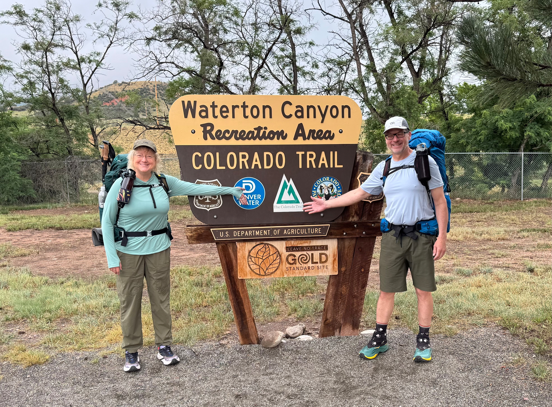
We arrived at the trailhead chauffeured by my dad about 7:15. We got our obligatory photos at the trailhead sign and we were on the trail a couple minutes before 7:30. It was a cloudy morning and we started our walk in some rain showers. One of the showers was significant enough that we put our umbrellas up, but the other ones were all pretty short and light.

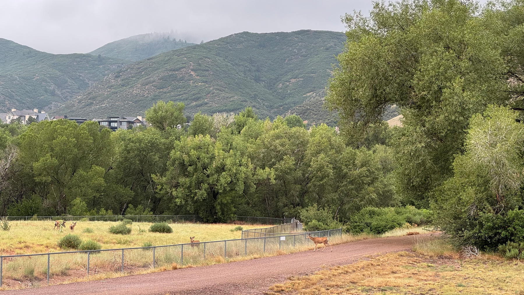
We did see some wildlife: we saw a group of deer right near the start of the trail, a Heron, and some cormorants. We were not able to see the elusive bighorn sheep that frequent the Waterton Canyon.


We finished the six basically flat miles on the Waterton Canyon Road in about three hours after a couple of short stops. Where the dam for the reservoir is there was a picnic shelter where we ate the first half of our subway sandwiches.
After that, the road begins to climb for about a half a mile, and then you leave the graded road and follow a sort of Jeep road for a short distance, and then it turns into a regular trail. Once you get on that trail, the climbing really begins. We climbed up to the top of a ridge and found a bench that was placed in memory of Lawrence Stilwell. This is known as Lenny’s rest. We took a little break here And then continued down the other side of the ridge towards Bear Creek.

Bear Creek is still barely flowing and we stopped here to eat the other half of our sandwiches and filter some water for the rest of the trail today. A young man from Nashville arrived shortly after we did and also took a break and filtered some water so we had some good conversation with him. Interestingly, he seems to have read and/or seen a lot of the same things that we have so we have some similar gear and got a lot of the same information. We may not see him again on the trail because he is planning on doing a lot more miles per day than we are.
After leaving Bear Creek the trail climbs for about 4 miles. There are a lot of switchbacks and the slope is mostly gradual, but there were a few pretty steep sections and our legs were definitely wearing down. We took another break at the trails highest point for the day, which was at about trail mile 12.

Then the trail slowly switchbacked down toward the South Platte River, meeting it at about mile 16. We found a really nice camp spot just off the trail but tucked between some juniper trees, just a couple tenths of a mile before the river, around 6:00. Sixteen miles over ten and a half hours.

We were both pretty tired but we made a “boil in the bag dinner” and then walked down to the river to get some more water. By that time it was starting to get dark so we went to bed around 9:00. Unfortunately, it was around then that gusty winds started, and we tried to fall asleep as distant lightning flashed. It rained lightly for some time, but we managed to fall asleep.

Colorado Trail Journey Begins
We are finally on the Colorado Trail!
There were several steps to get here, and we have received a lot of help from our family and friends. Our neighbors drove us to the bus stop. The bus (driven by our bus driver neighbor!) took us to the light rail. The light rail took us to the airport where we stayed at a hotel for our early morning flight. The flight took us to New Mexico, where some of Julie’s father’s friends picked us up at the airport and brought us to his house.
We spent some time with Julie’s father and did some light hiking up at 7000 feet elevation to try to start getting acclimated to the altitude and, as it turned out, also getting acclimated to 90 degrees and sunny weather.
Then we drove up to Colorado where we visited my sister at 8300 feet , then to Denver where we stayed with my father while we did our final preparations.
After a day of visiting with family, my dad drove us here to the trailhead early in the morning. My dad is a critical part of our support team - he is our emergency contact, he will bring a box of stuff to us at trail mile 70 on day five so that we can change our minds and exchange things that we brought with different stuff, and also get a little more food. He will mail a resupply box to us around mile 200, and likely will be our ride out if something goes wrong and we have to leave the trail. Assuming everything goes as planned, he will pick us up in Durango at the end of the hike.
Those same friends who picked us up at the airport are going to let us stay at their condo in Frisco at trail mile 104. We also have friends who are looking in on our house, and others helping take care of our garden while we are away for two months.
Some people do this trail without all this support, but we feel very fortunate to have so many friends and family members making this easier for us.
We plan to keep posting updates here at this URL as we make progress on the trail. We will probably only be able to update the blog when we are in towns with good service (about once a week), but we may occasionally be able to post from ridge tops or other places with cell service.